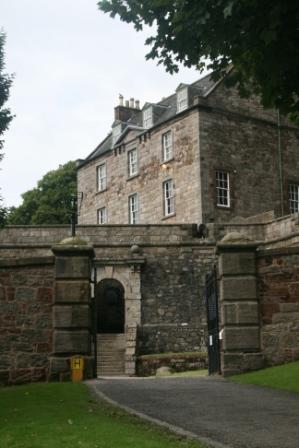
Dumbarton Castle
 South of the centre of Dumbarton rises the
240ft high twin peaked volcanic plug of Dumbarton Rock, with the River
Clyde on one side and the River Leven on two more. The Britons had a
fortress here before the Romans left these shores, and it was still
home to a military base as recently as World War II: a continuity of
use of over 1500 years. South of the centre of Dumbarton rises the
240ft high twin peaked volcanic plug of Dumbarton Rock, with the River
Clyde on one side and the River Leven on two more. The Britons had a
fortress here before the Romans left these shores, and it was still
home to a military base as recently as World War II: a continuity of
use of over 1500 years.
There are three things you need to know before
visiting Dumbarton Castle. The first is that you will need to climb
large numbers of steps in order to get anywhere at all on the rock.
The second is that there have been three quite different stages of
development on Dumbarton Rock, and what you see today is mostly only
the most recent phase, which swept away much of what had preceded it.
And the third is that though a visit may leave you wondering whether
Dumbarton Castle really is a castle in any traditional sense, it is a
fascinating experience, and well worth making a detour to see.
The presence of a settlement here is first
recorded in a letter St Patrick wrote to King Ceretic, the British
King of Strathclyde at Alcluith (or Clyde Rock) in about AD450. In it
he complained about a raid the Britons had made on his Irish converts.
This date is supported by archeological evidence (fragments of wine
amphoras) that suggest that the residents of Dumbarton Rock traded
with the Romans, possibly before their departure from Britain in
AD367.
The Dark Age history of Alcluith is unclear,
though the King of the Britons of Strathclyde in about AD570 was
Rhydderich Hael, who features in Norse legends. It is said that during
his reign Merlin stayed at Alcluith. In 756 the first (and second)
losses of Dumbarton Rock were recorded. A joint force of Picts and
Northumbrians captured Alcluith after a siege, only to lose it again a
few days later. And in 780 Alcluith was burned down: who by, and why,
is unclear.
By 870 Dumbarton Rock was home to a tightly
packed British settlement that served as a fortress and as the capital
of Strathclyde. Buildings would have occupied every even vaguely flat
space on the rock. But then the Vikings attacked: Ivar Beinlaus en
route from capturing York, and Olaf the White from Ireland. They
besieged Alcluith for 15 weeks before destroying it, carrying the loot
and the survivors off as slaves to Ireland in a fleet of 200 longships.
The Kingdom of Strathclyde remained a separate
force in Scottish history until 1018, when Malcolm II incorporated it
following his defeat of the Northumbrians at the Battle of Carham.
This ended the first of the three phases of development on Dumbarton
Rock and signalled the start of the second.
By 1222 there was reference to a "new castle"
built here. Dumbarton at the time had great strategic significance
because much of the west of Scotland was under the control of the King
of Norway, including the islands of Arran and, intermittently, Bute in
the Clyde Estuary. The defeat of King Håkon of Norway by Alexander III
(and by the weather) at the
Battle of Largs
in 1263 meant Dumbarton was no longer an outpost on a warring
frontier, but it remained central to Scottish history over the
following centuries.
Very little is know about the way Dumbarton
Castle evolved over the period between 1200 and 1600. It certainly
looked more like a traditional castle, with extensive development on
"The Beak" the flatter more easterly summit, as well as across the gap
between the peaks and down the steep slope on the Clyde side of the
rock. It also had two gates. One faced the River Clyde as it does
today, the other, the North Entry, faced the town of Dumbarton.
Only two of the surviving structures date back
to this period. The Portcullis Arch above the Guard House was built in
the 1300s, and the Guard House itself dates back to about 1580.
During this middle phase of its life, Dumbarton
Castle served as a royal castle, a place of sanctuary in times of
trouble, and a convenient place to keep prisoners secure. It also saw
far more than its share of action.
King David II sought refuge at Dumbarton in
1333 after the Scots lost the
Battle of Haildon Hill, and sailed from here to France. In 1435
James I's daughter also went to France from here to marry Louis, the
heir to the French throne. In 1489 James IV besieged the castle twice
to suppress a rebellion by Lord Darnley. The great gun Mons Meg was
used in the second, successful, siege.
In the turbulence following the
Battle of Flodden, Dumbarton
Castle was captured in 1514 by the Earl of Lennox, who burrowed under
the North Gate under cover of a stormy night. In 1523 the Castle was
briefly garrisoned with French troops by the Duke of Albany, though by
1530 it was held by James V. In 1545 Dumbarton was captured on behalf
of the child Mary Queen of Scots, who came here for safety in 1548
before sailing for France. She next visited Dumbarton Castle after her
return to Scotland, 13 years later. In 1568, she was moving towards
Dumbarton Castle after her escape from
Lochleven Castle when her forces were intercepted and defeated at
the Battle of Langside. Mary
then fled to England and captivity, never to return.
But Mary's supporters in Scotland were still
active and still held Dumbarton Castle. On 1 May 1571 troops under the
command of a Captain Crawford captured the castle after climbing the
cliffs on the north side of The Beak in darkness, and Mary's remaining
supporters in the west of Scotland either fled or were killed.
Dumbarton Castle's third phase of development
followed a period of decline and disrepair. It was considered
incapable of being defended by the time of Cromwell's arrival in 1652,
and surrendered without a fight. Over the period from 1670 to 1790
most of the earlier buildings were swept away and replaced with what
you can see today. These were designed first to enable Dumbarton to
provide a secure base for Government Troops during the Jacobite
uprisings of 1689, 1715 and 1745. Later the primary concerns were to
defend the River Clyde against French naval attack, and to accommodate
French Prisoners.
 |
 |
Aerial photography
by Alex Doherty |
The Governor's House and King George's Battery
that dominate the Clyde side of the rock were built in 1735. In 1795
the North Gate facing the town was blocked and replaced by the Duke of
York's Battery. Of the various buildings also erected at the time in
the cleft between the peaks, only the "French Prison" remains. The
other notable building today is the Magazine, built on The Beak in
1748 after earlier buildings had been demolished. This was designed to
survive a direct hit by an artillery shell, an event that had largely
destroyed Fort Augustus in February 1746.
The military left Dumbarton Castle in 1865,
which by then was already becoming a tourist attraction. The army took
it over again in 1914, and in 1939, and the castle saw its last action
in May 1941 when a German aircraft dropped four bombs on Dumbarton
Rock during a raid on the Clyde. Today it is in the care of Historic
Scotland.
|


